


 EM News
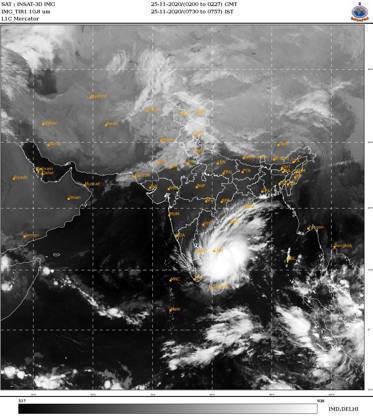
The cyclonic storm ‘NIVAR” over southwest Bay of Bengal moved westwards with a speed of 05 kmph during past six hours and lay centred at 1730 hrs IST of 24th November, 2020 over southwest Bay of Bengal about 320 km east-southeast of Cuddalore, about 350 km southeast of Puducherry and 410 km east southeast of Chennai. It is very likely to intensify further into a severe cyclonic storm during next 06 hours and into a very severe cyclonic storm during subsequent 12 hours.
Earlier, at a joint Press conference with the DG, NDRF in New Delhi, Dr. M. Mohapatra DG IMD informed that It is very likely to move west-northwestwards for next 06 hours and then northwestwards. It is very likely to cross Tamil Nadu and Puducherry coasts between Karaikal and Mamallapuram around Puducherry during 25th November 2020 late evening as a very severe cyclonic storm with a wind speed of 120-130 kmph gusting to 145 kmph, he said.
Warnings:
(i) Rainfall
Dr. Mohapatra said that fairly widespread to widespread rainfall/thunderstorm activity is very likely over coastal and north interior Tamilnadu, Puducherry & Karaikal during 24th to 26th November and over south coastal Andhra Pradesh, Rayalaseema during 25th to 26thand southeast Telangana during 26thNovember, 2020.Isolated extremely heavy rainfall activity also very likely over coastal & north interior Tamilnadu & Puducherry(Pudukottai, Thanjavur, Tiruvarur, Karaikal, Nagapattinam, Cuddalore, Chennai, Kanchipuram, Chengalpattu, Myladuthirai, Ariyalur & Perambalurdistricts during 24th and Kadalur, Kallakurchi, Puducherry, Villupuram, Tiruvannamalai, Myladuthirai, Chennai, Kanchipuram, Chengalpattu, Ariyalur, Perambalur and Karaikaldistricts during 25th; over Nellore and Chittoor districts of Andhra Pradeshon 25th and over Rayalseema & southeast Telangana on 26th November,2020.
(ii) Wind warning
(iii) Sea condition
The IMD Director General cautioned that the Sea condition is high over Southwest Bay of Bengal and rough to very rough along & off Tamil Nadu, Puducherry, south Andhra Pradesh coasts and over Gulf of Mannar. He said, it would gradually become very highover the southwest Bay of Bengal from 24th November night and phenomenal over the same area from noon to night of 25th November.
(iv) Strom Surge Warning
According to Dr. Mohapatra, tidal wave of about 1-1.5m height above the astronomical tide is very likely to inundate the low lying areas of north coastal districts of Tamilnadu & Puducherry near the place of landfall.
(v) (a)Damage expected over Nagapattinam, Myladuthurai, Cuddalore, , Villupuram & Chengalpattu districts of Tamilnadu and Karaikal & Puducherry:
Dr. Mohapatra also pointed out that in the wake of the cyclone, total destruction of thatched houses and extensive damage to kutcha houses might be expected. Some damage to old pucca houses, andpotential threat from flying objects, are also expected, he said. Among other expected damages, he pointed out the following:
(v) (b)Damage expected over Tiruvarur, Kanchipuram, Chennai, Tiruvallaur districts of Tamilnadu and adjoining Andhra Pradesh:
(vi) Fishermen Warning & Action Suggested:
Dr. Mohapatra advised total suspension of fishing operations in the affected areas. He enumerated other measures like:
Movement in motor boats and small ships unsafe.
#nivarcyclone #tamilnanu #puduchery #weatherwarning #warning

